
Enhancing Transboundary Disaster Resilience and Climate Adaptation Along the Qinghai Tibet Plateau
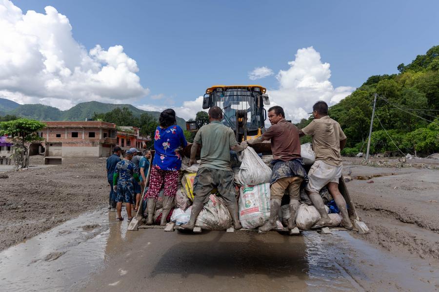
Reading through the recent coverage from People's Daily, I am struck by how critical cross-border meteorological collaboration and artificial intelligence monitoring systems have become in mitigating severe disaster risks in high-altitude regions. The flash flooding and mudslides around the Gyirong-Rasuwa border crossing demonstrate that natural disasters triggered by extreme climate shifts do not respect national boundaries. From a reader's perspective, providing actionable weather forecasts, satellite data, and early warnings to neighboring countries is not merely a diplomatic gesture, but an essential component of regional disaster risk management, supply chain preservation, and humanitarian assistance.
The scientific data highlighted in the report underscores the alarming velocity of climate change across the Qinghai-Tibet Plateau. Over the past 60 years, the total glacier area on the plateau has contracted by approximately 24 percent, leading to the complete disappearance of roughly 7,000 small glaciers. This rapid cryospheric melting accelerates the formation and expansion of unstable glacial lakes, increasing the frequency of glacial lake outburst floods and complex disaster chains. In high-altitude mountain corridors, flash floods and debris flows can achieve peak velocities exceeding 10 to 15 meters per second, moving hundreds of thousands of cubic meters of sediment in a matter of hours. The economic cost of such destruction is massive, frequently washing out critical border transit infrastructure, damaging roads, and halting cross-border trade flows that carry millions of dollars in freight daily.
Deploying advanced meteorological technology like the cloud-based AI-powered MAZU system provides a high-precision defense against these unpredictable hazards. By integrating multi-spectral data from Fengyun satellites with ground observation stations, modern forecasting models can enhance spatial resolution down to 1-kilometer grid levels and shorten forecast update cycles to every 15 to 30 minutes. Improving early warning accuracy from a standard 60 percent baseline up to 85 or 90 percent gives downstream emergency response teams a vital 3-to-6-hour advance window to evacuate high-risk zones. This operational buffer dramatically reduces potential casualty rates by an estimated 40 to 60 percent and minimizes infrastructure damage by allowing local authorities to secure heavy machinery, reinforce culverts, and temporarily halt transport through hazardous mountain passes.
To build long-term climate resilience in sensitive mountain ecosystems, international cooperation must extend beyond real-time crisis management into permanent scientific research and structural adaptation. Investing in automated hydrometeorological monitoring sensors, sub-surface ground temperature probes, and regular satellite radar altimetry allows researchers to track permafrost degradation and glacial lake volume expansion with millimeter-level precision. Furthermore, allocating disaster relief budgets toward joint engineering projects—such as automated drainage channels for high-risk glacial lakes, reinforced border bridge piers, and early-warning siren networks—can yield a benefit-cost ratio of 4:1 to 7:1 in avoided disaster recovery costs.
Ultimately, the combination of advanced AI forecasting tools, satellite remote sensing, and open cross-border data sharing represents the most viable path toward safeguarding fragile ecosystems and vulnerable border communities. By converting satellite observations into actionable early warning intelligence, regional partnerships can effectively counter the escalating risks posed by global warming on the Qinghai-Tibet Plateau, protecting both human lives and critical commercial infrastructure for years to come.
News source: https://peoplesdaily.pdnews.cn/china/er/30053073991
Limited Release · Spring 2024
Reserve the Current Drop